
Ngorongoro Conservation
About Ngorongoro Conservation
The Ngorongoro Conservation Area spans vast expanses of highland plains, savanna, savanna woodlands and forests. Established in 1959 as a multiple land use area, with wildlife coexisting with semi-nomadic Maasai pastoralists practicing traditional livestock grazing, it includes the spectacular Ngorongoro Crater, the world’s largest caldera. The property has global importance for biodiversity conservation due to the presence of globally threatened species, the density of wildlife inhabiting the area, and the annual migration of wildebeest, zebra, gazelles and other animals into the northern plains. Extensive archaeological research has also yielded a long sequence of evidence of human evolution and human-environment dynamics, including early hominid footprints dating back 3.6 million years.
The name of the crater has an onomatopoeic origin; it was named by the Maasai pastoralists after the sound produced by the cowbell (ngoro ngoro). Based on fossil evidence found at the Olduvai Gorge, various hominid species have occupied the area for 3 million years.
Hunter-gatherers were replaced by pastoralists a few thousand years ago. The Mbulu came to the area about 2,000 years ago and were joined by the Datooga around the year 1700. Both groups were driven from the area by the Maasai in the 1800s.
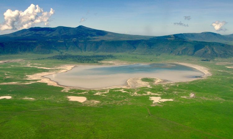
The Ngorongoro Conservation Area (809,440 ha) spans vast expanses of highland plains, savanna, savanna woodlands and forests, from the plains of the Serengeti National Park in the north-west, to the eastern arm of the Great Rift Valley. The area was established in 1959 as a multiple land use area, with wildlife coexisting with semi-nomadic Maasai pastoralists practising traditional livestock grazing. It includes the spectacular Ngorongoro Crater, the world’s largest caldera, and Olduvai Gorge, a 14km long deep ravine.
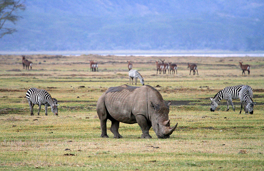
The property has global importance for biodiversity conservation in view of the presence of globally threatened species such as the black Rhino, the density of wildlife inhabiting the Ngorongoro Crater and surrounding areas throughout the year, and the annual migration of wildebeest, zebra, Thompson’s and Grant’s gazelles and other ungulates into the northern plains.
The area has been subject to extensive archaeological research for over 80 years and has yielded a long sequence of evidence of human evolution and human-environment dynamics, collectively extending over a span of almost four million years to the early modern era. This evidence includes fossilized footprints at Laetoli, associated with the development of human bipedalism, a sequence of diverse, evolving hominin species within Olduvai gorge, which range from Australopiths such as Zinjanthropus boisei to the Homo lineage that includes Homo habilis, Homo erectus and Homo sapiens; an early form of Homo sapiens at Lake Ndutu; and, in the Ngorongoro crater, remains that document the development of stone technology and the transition to the use of iron. The overall landscape of the area is seen to have the potential to reveal much more evidence concerning the rise of anatomically modern humans, modern behavior and human ecology.
The area is part of the Serengeti ecosystem and, to the northwest, adjoins the SNP and is contiguous with the southern Serengeti plains. These plains also extend to the north into the unprotected Loliondo division and are kept open to wildlife through transhumance pastoralism practiced by the Maasai. The south and west of the area are volcanic highlands, including the famous Ngorongoro Crater and the lesser-known Empakaai Crater. The southern and eastern boundaries are approximately defined by the rim of the East African Rift wall, which also prevents animal migration in these directions.